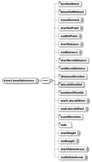
diagram | ![]() |
||||||||||||
namespace | http://www.LRMS-Adopted-02-00-00 | ||||||||||||
children | locationName linearRefMethod transElement startRefPoint endRefPoint startDistance endDistance startNormDistance endNormDistance distanceDirection lateralOffsetRef positiveOffsetDir startLateralOffset endLateralOffset travelDirection side startHeight endheight startAdminAreas endAdminAreas | ||||||||||||
used by |
|
||||||||||||
attributes |
|
||||||||||||
source | <xs:complexType name="LinearReference"> <xs:sequence> <xs:element name="locationName" type="Text-name255" minOccurs="0"/> <xs:element name="linearRefMethod" type="LRMethod" minOccurs="0"/> <xs:element name="transElement" type="StreetInfo" minOccurs="0"/> <xs:element name="startRefPoint" type="PointLocation" minOccurs="0"/> <!-- Start (first) reference point --> <xs:element name="endRefPoint" type="PointLocation" minOccurs="0"/> <!-- End (second_ reference point --> <xs:element name="startDistance" type="Distance" minOccurs="0"/> <!-- From start of element or the start reference point --> <xs:element name="endDistance" type="Distance" minOccurs="0"/> <!-- From start of element or the second reference point --> <xs:element name="startNormDistance" type="NormalizedDistance" minOccurs="0"/> <!-- Percentage of link length from start of element or start reference point to start of referenced link. --> <xs:element name="endNormDistance" type="NormalizedDistance" minOccurs="0"/> <!-- Percentage of link length from start of element or start reference point to end of referenced link. Note: normalized distances should only be used for references involving known link lengths. --> <xs:element name="distanceDirection" type="Direction" minOccurs="0"/> <!-- Direction for distance measures along the transport element --> <xs:element name="lateralOffsetRef" type="LROffsetRef"/> <!-- Defines from where lateral offset is measured. 'centerline' is the default value --> <xs:element name="positiveOffsetDir" type="LRPosOffsetDir" minOccurs="0"/> <!-- positive direction of a lateral offset. 'right' is the default value --> <xs:element name="startLateralOffset" type="Distance" minOccurs="0"/> <!-- Start offset perpendicular to the road --> <xs:element name="endLateralOffset" type="Distance" minOccurs="0"/> <!-- End offset perpendicular to the road --> <xs:element name="travelDirection" type="Direction" minOccurs="0"/> <!-- Direction the vehicle is traveling; may be different from the distance direction --> <xs:element name="side" type="Side" minOccurs="0"/> <!-- of the referenced point or link --> <xs:element name="startHeight" type="Height" minOccurs="0"/> <!-- of the first (start) referenced point --> <xs:element name="endheight" type="Height" minOccurs="0"/> <!-- of the second (ending) point of a link --> <xs:element name="startAdminAreas" type="AdminAreaGroup" minOccurs="0"/> <!-- of the first (start) referenced point --> <xs:element name="endAdminAreas" type="AdminAreaGroup" minOccurs="0"/> <!-- of the second (ending) point of a link --> </xs:sequence> <xs:attribute name="locationID" type="String-index64"/> </xs:complexType> |
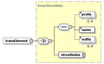
diagram | ![]() |
||||||||
type | lrms:Text-name255 | ||||||||
properties |
|
||||||||
facets |
|
||||||||
source | <xs:element name="locationName" type="Text-name255" minOccurs="0"/> |
diagram | ![]() |
||||||||
type | lrms:LRMethod | ||||||||
properties |
|
||||||||
source | <xs:element name="linearRefMethod" type="LRMethod" minOccurs="0"/> |
diagram | ![]() |
||||||||
type | lrms:StreetInfo | ||||||||
properties |
|
||||||||
children | prefix name suffix streetIndex | ||||||||
source | <xs:element name="transElement" type="StreetInfo" minOccurs="0"/> |
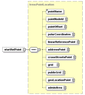
diagram | ![]() |
||||||||||||
type | lrms:PointLocation | ||||||||||||
properties |
|
||||||||||||
children | pointName pointNodeId pointOffset polarCoordinates linearReferencePoint addressPoint crossStreetsPoint grid publicGrid geoLocationPoint adminArea | ||||||||||||
attributes |
|
||||||||||||
source | <xs:element name="startRefPoint" type="PointLocation" minOccurs="0"/> |
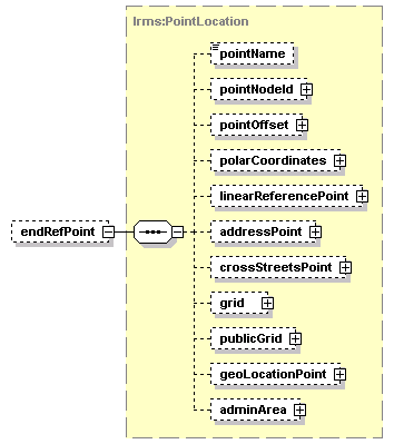
diagram | ![]() |
||||||||||||
type | lrms:PointLocation | ||||||||||||
properties |
|
||||||||||||
children | pointName pointNodeId pointOffset polarCoordinates linearReferencePoint addressPoint crossStreetsPoint grid publicGrid geoLocationPoint adminArea | ||||||||||||
attributes |
|
||||||||||||
source | <xs:element name="endRefPoint" type="PointLocation" minOccurs="0"/> |
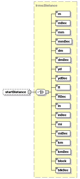
diagram | ![]() |
||||||||
type | lrms:Distance | ||||||||
properties |
|
||||||||
children | m mDec mm mmDec dm dmDec yd ydDec ft ftDec in inDec mi miDec km kmDec block blkDec | ||||||||
source | <xs:element name="startDistance" type="Distance" minOccurs="0"/> |
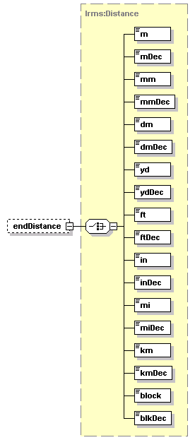
diagram | ![]() |
||||||||
type | lrms:Distance | ||||||||
properties |
|
||||||||
children | m mDec mm mmDec dm dmDec yd ydDec ft ftDec in inDec mi miDec km kmDec block blkDec | ||||||||
source | <xs:element name="endDistance" type="Distance" minOccurs="0"/> |
diagram | ![]() |
||||||||
type | lrms:NormalizedDistance | ||||||||
properties |
|
||||||||
facets |
|
||||||||
source | <xs:element name="startNormDistance" type="NormalizedDistance" minOccurs="0"/> |
diagram | ![]() |
||||||||
type | lrms:NormalizedDistance | ||||||||
properties |
|
||||||||
facets |
|
||||||||
source | <xs:element name="endNormDistance" type="NormalizedDistance" minOccurs="0"/> |
diagram | ![]() |
||||||||
type | lrms:Direction | ||||||||
properties |
|
||||||||
source | <xs:element name="distanceDirection" type="Direction" minOccurs="0"/> |
diagram | ![]() |
||||
type | lrms:LROffsetRef | ||||
properties |
|
||||
source | <xs:element name="lateralOffsetRef" type="LROffsetRef"/> |
diagram | ![]() |
||||||||
type | lrms:LRPosOffsetDir | ||||||||
properties |
|
||||||||
source | <xs:element name="positiveOffsetDir" type="LRPosOffsetDir" minOccurs="0"/> |
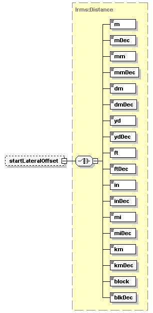
diagram | ![]() |
||||||||
type | lrms:Distance | ||||||||
properties |
|
||||||||
children | m mDec mm mmDec dm dmDec yd ydDec ft ftDec in inDec mi miDec km kmDec block blkDec | ||||||||
source | <xs:element name="startLateralOffset" type="Distance" minOccurs="0"/> |
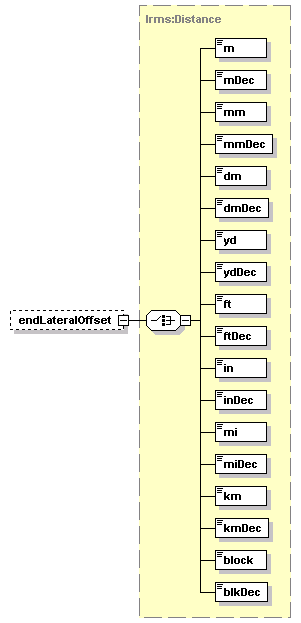
diagram | ![]() |
||||||||
type | lrms:Distance | ||||||||
properties |
|
||||||||
children | m mDec mm mmDec dm dmDec yd ydDec ft ftDec in inDec mi miDec km kmDec block blkDec | ||||||||
source | <xs:element name="endLateralOffset" type="Distance" minOccurs="0"/> |
diagram | ![]() |
||||||||
type | lrms:Direction | ||||||||
properties |
|
||||||||
source | <xs:element name="travelDirection" type="Direction" minOccurs="0"/> |
diagram | ![]() |
||||||||
type | lrms:Side | ||||||||
properties |
|
||||||||
source | <xs:element name="side" type="Side" minOccurs="0"/> |
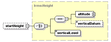
diagram | ![]() |
||||||||
type | lrms:Height | ||||||||
properties |
|
||||||||
children | altitude verticalDatum verticalLevel | ||||||||
source | <xs:element name="startHeight" type="Height" minOccurs="0"/> |
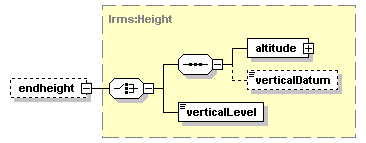
diagram | ![]() |
||||||||
type | lrms:Height | ||||||||
properties |
|
||||||||
children | altitude verticalDatum verticalLevel | ||||||||
source | <xs:element name="endheight" type="Height" minOccurs="0"/> |
diagram | ![]() |
||||||||
type | lrms:AdminAreaGroup | ||||||||
properties |
|
||||||||
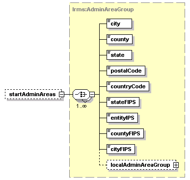
children | city county state postalCode countryCode stateFIPS entityIPS countyFIPS cityFIPS localAdminAreaGroup | ||||||||
source | <xs:element name="startAdminAreas" type="AdminAreaGroup" minOccurs="0"/> |
diagram | ![]() |
||||||||
type | lrms:AdminAreaGroup | ||||||||
properties |
|
||||||||
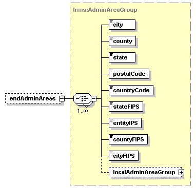
children | city county state postalCode countryCode stateFIPS entityIPS countyFIPS cityFIPS localAdminAreaGroup | ||||||||
source | <xs:element name="endAdminAreas" type="AdminAreaGroup" minOccurs="0"/> |