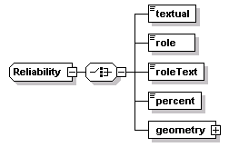
<xs:choice>
<xs:element name="textual" type="FreeText"/>
<!-- free text concerning Reliability factors -->
<xs:element name="role" type="RoleInEvent"/>
<!-- an ENUMERATED list of sources (driver, witness, officer ... )
note that if desire contact data for such persons,
can record under "Witness-list" DF in the Description
Submessage of IDX -->
<xs:element name="roleText" type="FreeText"/>
<!-- a free text Roles in the event -->
<xs:element name="percent">
<xs:simpleType>
<xs:restriction base="xs:unsignedByte">
<xs:maxInclusive value="100"/>
</xs:restriction>
</xs:simpleType>
</xs:element>
<!-- a percentage to be used in the general value case
use zero for unknown
use 100 as the most confidence -->
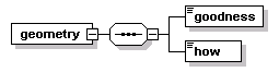
<xs:element name="geometry">
<xs:complexType>
<xs:sequence>
<xs:element name="goodness" type="atis:Location-quality"/>
<!-- [SAE.J2313.Location-Quality]
what level of accuracy do we have
global positioning system (GPS) , off a map,
differential-GPS, unknown -->
<xs:element name="how" type="atis:Location-tech"/>
<!-- [SAE.J2313.Location-Tech]
how was position determined
1meter, <5meter, <12meter, <50meter, <125meter,
<500meter, <1250meter, unknown -->
</xs:sequence>
</xs:complexType>
</xs:element>
<!-- used for location qualities
taken from SAE work on position for MAYDAY -->
</xs:choice>
</xs:complexType>